Description:
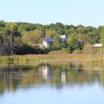
Lake Overview
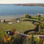
Lake managers and water quality experts have developed standard size and shape measurements to describe the physical features of lakes. These characteristics can provide insights into a lake’s productivity and sensitivity to changes. The simplest of these is surface area. Crooked Lake, the largest lake in the Pickerel-Crooked Watershed, has a surface area of 2,371 acres (960 hectares). The maximum width is 1.92 miles (3.10 km) and its maximum length is 3.48 miles (5.60 km). Crooked Lake has an average depth of approximately 9.8 feet (3.00 m). The maximum depth, measuring approximately 61 feet (18.60 m) is found in the north-central portion of the lake basin, west of Oden Island. The lake contains large expanses of shallow water suitable for development of weed beds which provide favorable habitat for fish.
Pickerel Lake is approximately half the size of Crooked, with a surface area of 1,055 acres (427 hectares). The maximum length and width are 2.55 miles (4.10 km) and 1.06 miles (1.70 km), respectively. Pickerel Lake has an average depth of 12.8 feet (3.90 m) and a maximum depth of approximately 70 feet (21.30 m). The maximum depths are located in the northwest portion of the lake basin near the Pickerel-Crooked Channel. Similar to Crooked Lake, Pickerel Lake contains large expanses of shallow water suitable for the growth of weed beds and fish communities.
Long before the arrival of Europeans, the northern portion of Michigan’s Lower Peninsula was home to the Ottawa (Odawa) nation. The total population of the early Ottawa is not known, though it has been estimated to be somewhere between 20,000 and 100,000. The Ottawa made their home here for hundreds of years, establishing and maintaining villages along the Lake Michigan shoreline and along the Inland Waterway. These villages were connected by a series of footpaths which allowed the natives to travel overland (many of our highways roughly follow these paths). More important for travel were the waterways, by which distance could be covered quickly. The Inland Waterway, connecting Crooked Lake at the western side of the lower peninsula with Lake Huron at Nonpoint Source Pollution Management Plan 9 Cheboygan, was the most efficient travel option. Using canoes, the Ottawa could travel from Crooked Lake to hunting grounds, seasonal fishing spots, and neighboring villages along the Crooked River, Burt Lake, Indian River, Mullet Lake, the Cheboygan River and, finally, Lake Huron. This route avoided the more challenging and dangerous trip around the peninsula on Lake Michigan.
In 1808, John Jacob Astor established the American Fur Company on Mackinac Island, employing 2,000 voyagers during trapping season. The heavy predation decimated the populations of beaver, otter, mink, fox and other animals. By 1825, Astor’s fur company was finished.
Land was cheap and easy to obtain in the early and mid-1800’s. This fostered the rapid growth of the logging industry. The work was difficult and slow, since it was all done by hand. With the opening of railroads in the region, the lumber industry boomed, reaching its peak after the Civil War, and continuing for the next half-century. Virtually all the forested land in northern Michigan was logged during this period. By the early 1900’s the lumber industry had sharply declined.
The land was clearcut rapidly during this period, with no thought to environmental concerns. According to F. Clever Bald in Michigan In Four Centuries, “The loggers had no thought for the future. ‘Cut and get out’ was their motto. There was sharp competition, and to make money they believed that they had to clear the land as quickly as possible.” When the trees were cleared from an area, there was generally nothing left, but slashings and remains of trees too small to cut. As these branches and wood debris dried, they became prime fuel for forest fires. Disastrous forest fires broke out in the 1870’s and 1880’s due to these careless logging practices, destroying many homes and villages, and consuming valuable stands of remaining timber.
Throughout this period of settlement and development, the Inland Waterway constituted an important transportation link between otherwise remote areas. Before the construction of railroads, the Waterway was the only means of transporting timber to the mills for processing and distribution. Logs cut along streams or rivers were heaped on the banks during winters, and then rolled into the water after the spring thaw to float downstream to towns near the rivermouths where they were converted into lumber. From there the lumber would be loaded on vessels and transported to various ports along the Great Lakes. Pickerel-Crooked Lakes Watershed.
Geographic Description:
Location, Size, and Description of Watershed
The combined watershed of Crooked and Pickerel Lakes, encompassing approximately 62,972 acres, is fairly small when compared to the other watersheds within the larger Cheboygan River Watershed. (By comparison, Burt Lake’s Watershed measures more than 250,000 acres; the Mullett Lake Watershed covers more than 162,000 acres). The Crooked Lake Watershed is long and narrow and spans 20,093 acres. Pickerel Lake’s Watershed covers 33,879 acres; it is somewhat circular in shape, with the lake in the northwest corner.
The Pickerel-Crooked Lakes Watershed can be broken down into a group of subwatersheds, all of which eventually flow, directly or indirectly into Crooked Lake. This series of streams and lakes, with Crooked Lake at its center, is part of the larger Cheboygan River Watershed. The Pickerel-Crooked Lakes Watershed is composed of the following subwatersheds: Minnehaha Creek, including the West Branch of the Minnehaha and Silver Creek, Mud Creek, Cedar Creek including Berry Creek, Round Lake Creek, Fish Hatchery Creek, Spring Lake, Mud Lake, and Round Lake. The ratio of the size of a lake’s entire watershed to the lake’s surface area is a descriptive statistic for indicating the susceptibility of the lake to pollution from the watershed. Lakes which have a large ratio of watershed to lake area are more susceptible to nutrient enrichment and other types of pollution from throughout the watershed than lakes with small ratios. Pickerel and Crooked Lakes combined watershed area is eighteen times higher than the combined surface area of the lakes, or 18:1. This is a fairly average ratio. (For comparison, Mullett Lake has a ratio of 9.74:1; Burt Lake is 14:1; the ratio for Black Lake, on the other hand, is 35.04:1). The Pickerel-Crooked Lakes Watershed is composed predominantly of undeveloped forest land. Other significant land uses within the watershed include agriculture and residential development found near the lake shores and in the villages of Conway and Oden.
Additional Publications:
| Title | Link |
|---|