Tip of the Mitt Watershed Council continues to be fully committed to protecting the lakes, streams, wetlands, and groundwater that help drive Northern Michigan’s economy and quality of life.
The work that we do every day is dependent on strong community partnerships. We are fortunate to live and work in communities that greatly appreciate our precious water resources.
This past spring, summer and fall, the Watershed Council’s efforts included surveying shorelines, potential septic pollution, endangered species, and aquatic invasive species, as well as conducting a watershed priority parcel analysis, an agricultural inventory, a corridor assessment, stormwater inventory, and forestry inventory. In addition to other methods, 90 miles were paddled by Watershed Council staff and student interns to accomplish this work.
Additionally, through dedicated community support, 32 sites on 26 lakes spread throughout the region were monitored weekly by 60 volunteers, and 25 sites on 16 streams were also monitored, once in the spring and once in the fall. Volunteers also monitored 3 stretches of Lake Michigan’s shoreline for avian botulism. Staff and five student interns also conducted water quality monitoring of 33 lakes and 11 streams as part of the Watershed Council’s Comprehensive Water Quality Monitoring program that takes place every three years.
The Watershed Council has four main monitoring programs:
Volunteer Stream Monitoring
Since 2004, volunteers have monitored streams throughout the Northern Lower Peninsula, covering 16 different streams. Volunteers wade into
Volunteer Lake Monitoring
The Watershed Council has coordinated and sponsored the Volunteer Lake Monitoring Program since 1986. Presently, volunteers monitor 27
Comprehensive Water Quality Monitoring
The Comprehensive Water Quality Monitoring Program was launched by Tip of the Mitt Watershed Council in 1987. Typically,
Comprehensive Water Quality Monitoring
The northern tip of the lower peninsula of Michigan contains some of the most pristine and healthy surface waters in the world. The high quality of the lakes and rivers reflect the largely natural state of the watersheds to which they pertain. Continuous non-disturbed terrestrial ecosystems, commonplace in Northern Michigan due to expansive areas of protected lands combined with sparse human settlement, are the foundation of the healthy aquatic ecosystems typical of the area. Land-cover statistics (for 2006), as determined by the NOAA Coastal Change Analysis Program, show that human impact remains low in the region with but 4% urban and 11% cultivated. However, US Census Bureau statistics reveal a gradual, yet steady population increase. In the forty-year period between 1960 -2000, the number of inhabitants in the northern counties of the Lower Peninsula has doubled. Furthermore, agricultural and urban land use each increased by over 1% from 2000 to 2006 (1% = 19,000 acres). This trend of increasing human populations and resultant landscape development stresses the need for monitoring the precious and valuable aquatic resources of the region.
The Comprehensive Water Quality Monitoring Program was launched by Tip of the Mitt Watershed Council in 1987. Initially, physical and chemical data were collected on 10 lakes but the program has progressively expanded to 58 lakes and rivers. Typically, data for nine parameters (temperature, dissolved oxygen, pH, conductivity, clarity, total phosphorous, total nitrogen, nitrate-nitrogen, and chloride) are collected at the surface, middle and bottom of the water column in each water body. This highly-accurate water quality data for lakes and rivers in Northern Michigan, collected consistently for the last 20+ years, have been compiled into a single database that can be used by staff to evaluate aquatic ecosystem health, examine trends within or among water bodies, and identify specific problems.
The water quality data is available to the general public through Water Reporter. We hope that the information made available via this web page can be used not only by Watershed Council members, but water resource professionals and other concerned individuals to further our common goal of protecting the water resources in Northern Michigan. If you have any questions or would like to learn more, please contact us at info@watershedcouncil.org
Volunteer Lake Monitoring
The Watershed Council has coordinated and sponsored the Volunteer Lake Monitoring Program since 1986. Presently, volunteers monitor 27 lakes spread throughout Antrim, Charlevoix, Cheboygan, Emmet, and Montmorency Counties (map below). The objectives of the program are to collect baseline data, characterize lake ecosystems, identify specific water quality problems, determine water quality trends, and, most importantly, inform and educate the public regarding water quality issues and aquatic ecology. Monitoring water quality does not ensure clean water, but rather provides valuable information to help protect and improve water quality in the lakes of northern Lower Peninsula of Michigan.
What does a Volunteer Lake Monitor do?
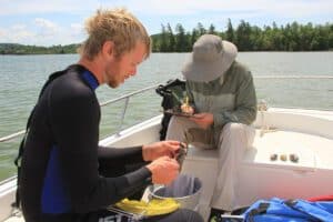
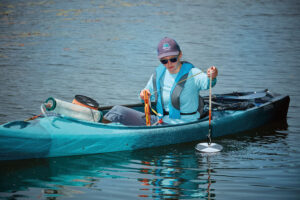
Volunteer lake monitors are often the first people to get their boats in the water in the spring. Starting in May or early June, they start their weekly visits to the deepest part of the lake to perform water quality monitoring activities. After anchoring the boat, the monitor begins by measuring water clarity with a Secchi disc.
The Secchi disc method was originally developed by Italian scientist, Pietro Angelo Secchi, in 1865 and, due to its simplicity and reliability, remains one of the most widely used water quality monitoring instruments today. It is a weighted disc, eight inches in diameter, which is painted black and white in alternating quarters. The monitor slowly lowers the Secchi disc over the shaded side of the boat and notes the depth where it disappears. The disc is lowered an additional two feet and then slowly raised until coming back into view. After noting the depth of reappearance, the average of the two depths is calculated and recorded. The deeper the Secchi disc depth, the clearer the water and generally the better the water quality.
Every other week, the monitor collects a water sample that is used to measure chlorophyll-a concentrations. Chlorophyll-a is a pigment found in all green plants, including algae. Measuring the amount of chlorophyll-a in a water sample provides a fairly accurate estimate of the amount of algae in the water. After determining the Secchi disc depth, the monitor collects the water sample in the same location. An ‘integrated sampling device’, which is a weighted container with a small hole on the top for water entry is lowered down through the water column to twice the Secchi disc depth. Research has determined that sunlight penetration, and therefore plant growth, is limited to approximately two times the Secchi depth. The water sample has to be representative of the entire water column, so the volunteer has to lower and raise the water sampling device at such a rate that twice the Secchi disc depth is reached and so that the container is not overflowing upon reaching the surface. Although more difficult than measuring Secchi depth, with practice our volunteers have consistently and quickly mastered this water sample collection method.
Once the water sample has been collected, the volunteer monitor uses a syringe filtering device that forces a specific volume of water through a filter paper. The filter paper is carefully placed into a test tube, wrapped in tinfoil to prevent exposure to sunlight and stored in the freezer. At the end of the sampling season, the accumulated test tubes with filters of all the lake volunteer monitors are delivered to a lab for analysis. A low level of chlorophyll-a indicates relatively low algae abundance and good to excellent water quality, while a high level of chlorophyll-a indicates dense algae growth and generally poor water quality.
Lake Characterization and Trophic Status
All lakes undergo a natural “aging” process called eutrophication. Lakes formed from glaciers are often very deep, with cold water, low levels of nutrients (phosphorus and nitrogen), and low biological productivity (relatively little aquatic life). As a lake “ages”, nutrient accumulation in the lake water and bottom sediments leads to greater biological productivity. Greater biological productivity leads to increased deposition of organic matter, which, combined with sediments that wash in during rain storms or snowmelt, cause the lake to become shallower and water temperatures to rise. In a natural setting this process occurs very slowly with little or no apparent change over the course of a human lifetime.
Human activities in a watershed often greatly accelerate the natural aging process of lakes by contributing additional nutrients and sediment. The acceleration of the process is called ‘cultural eutrophication’. When excessive nutrients are added to a lake, aquatic plants and algae thrive, resulting in excessive growth and large blooms. Excessive plant growth and large algae blooms can make swimming undesirable, make boating difficult and lead to the formation of ‘dead zones’. Dead zones are areas in a water body devoid of aquatic life due to dissolved oxygen depletion. Although aquatic plants and algae contribute oxygen to the ecosystem during day-time photosynthetic activities, they consume oxygen during the night while respiring, which (with excessive plant growth) can result in oxygen depletion. Increased sediment contributions from erosion, construction activities, and other human activity also accelerate the aging process.
Putting the Data to Work
Data collected by volunteers in the Volunteer Lake Monitoring program are used by Watershed Council staff to determine the current level of productivity or the “trophic status” of a lake using Carlson’s Trophic Status Index (TSI). This index utilizes Secchi disk depth recordings and chlorophyll-a measurements collected by volunteer monitors to calculate a lake score that ranges from 0-100. Lakes that score at the low end of the scale (TSI values ranging from 0-38), are considered to be oligotrophic with excellent water quality. A TSI score of 39-49 indicates a mesotrophic lake with good water quality and a TSI value of 50 or greater is considered to be a eutrophic lake with poor water quality. However, keep in mind that eutrophic lakes occur naturally during the aging process and do not necessarily reflect poor water quality.
Many beautiful high-quality lakes are being monitored by volunteers throughout the northern Lower Peninsula as a result of the Volunteer Lake Monitoring Program. Nevertheless, there is always a need for more volunteers. Call (231) 347-1181. Volunteering to be a monitor requires attending a half-day training session and then performing 1-4 hours of monitoring duties on a weekly basis from early June to late August (though some volunteers opt to start in May and continue until September or even October!). If you are interested in volunteering time to help monitor lake water quality, please contact the Watershed Council office at (231) 347-1181.
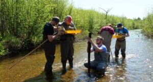
Volunteer Stream Monitoring
Since 2004, volunteers have monitored streams throughout the Northern Lower Peninsula, covering 16 different streams. Volunteers wade into local streams to collect a water sample, temperature, and most importantly macroinvertebrates. These little bugs can only survive in certain water conditions. Therefore their mere presence (or absence) serves as an indicator of water quality.
Program
Volunteer teams monitor the water quality of wadeable streams two times a year, during the spring (May) and fall (September). Teams consist of 3 or more volunteers, including a team leader, team collector and at least one picker. Prior to the outdoor field data collection volunteers receive specialized training. Following the field activities, volunteers and experts gather for an indoor identification session.
Trainings are held one to two times a year for team leaders and collectors. The training provides volunteers with information about program structure and goals, methodologies, field equipment, filling out data forms and biology of macroinvertebrates (e.g. aquatic insects, crustaceans, and other small aquatic “critters”). In addition, volunteers accompany Watershed Council staff to a nearby stream for an outdoor practicum to go over field methods and techniques. Leaders are trained to coordinate team activities in the field, collect pertinent information recorded on survey forms, and ensure quality control in data collection. Collectors are trained to thoroughly sample all habitat types found in stream ecosystems.
Watershed Council staff assign volunteers to teams and teams are given two sample sites to collect data from. On field days, volunteers meet at a predetermined sample site to begin their work.
Typically, volunteers spend 2-3 hours at each site collecting information. While leaders note relevant information on the survey form, collectors use a net to vigorously sample all habitats in the stream reach, emptying the net’s contents on trays so that pickers can pick and preserve specimens in alcohol for later identification.
Identification of aquatic macroinvertebrates takes place a few weeks after field day. Volunteers congregate at the Watershed Council office with macroinvertebrate samples in hand. The macroinvertebrates collected in the field are sorted by volunteers using trays and identification keys, largely based upon physical appearance, though utilizing volunteer taxanomic knowledge when able. Then, local experts trained in macroinvertebrate identification, sit down with volunteers to verify identifications. Then specimens are recorded by scientific names, counted, and preserved in fresh alcohol.
All data from field and indoor sessions is inputted into a database created and maintained by the Watershed Council. Information gathered by volunteers is used by Tip of the Mitt Watershed Council to determine the relative health of the stream, locate specific problem areas, compare sample sites to one another, and look at changes over time. Furthermore, data will be used by Michigan EGLE to identify sites that need further assessment and as supplemental data for statewide water resource management.
Get Involved
If you enjoy being outdoors and exploring the fascinating stream ecosystems of Northern Michigan, please consider becoming involved in the Tip of the Mitt Volunteer Stream Monitoring Program. Volunteer commitment is approximately two days a year (four half-days) and no experience is required. For further information or to volunteer for this project, please contact us by phone at (231) 347-1181.
Volunteer Stream Monitoring Quality Assurance Protection Plan (QAPP)
This project is funded by the Michigan Clean Water Corps (MiCorps). A QAPP was developed for the Tip of the Mitt Volunteer Stream Monitoring Program to comply with MiCorps grant funding requirements. The QAPP provides information about the stream monitoring program, including description, scope, and objectives, but more importantly outlines methods and protocols used for training, monitoring, sample processing, data management, and reporting. Following procedures detailed in the QAPP ensures that:
-high-quality, accurate data are collected by volunteers,
-collected specimens are identified with a high degree of confidence, and
-data are correctly inputted and carefully managed.
MiCorps has approved the Watershed Council’s QAPP, so volunteer water quality data are suitable for inclusion in the MiCorps data exchange, which is used as a screening tool to guide the Michigan Department of Environmental Quality’s assessments of Michigan rivers and streams.