
Description:
Certain cultural activities along the shoreline and throughout the watershed can contribute pollutants to the water. The pollutant of primary concern for Mullett Lake is nutrients, which are those
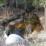
When the nutrient enrichment of a lake increases due to human activities, the rate of eutrophication can, and often does, become accelerated. Culturally-generated nutrients originate from such sources as construction activities, septic systems, sewer and industrial discharges, poor agricultural practices, storm water runoff, wetland destruction, and deposition of airborne pollutants. Development along the lakeshore is most likely to cause nutrient enrichment from these sources because of its close proximity to surface water. Other sources of nutrients to Mullett Lake originate throughout its watershed and are delivered to the lake by its tributary streams. These sources are often overlooked because they are widespread, inconspicuous, and difficult to assess. Many of these sources of pollution are referred to as nonpoint sources because they often do not have a single point of origin or discharge.
To Read More About the Mullett Lake Watershed, Follow the Story Map Below
Geographic Description:
The Mullett Lake Watershed is large, encompassing 744 square miles. However, the majority of the Watershed is located upstream from Burt Lake. The seven lakes which are found in this area act as nutrient and sediment traps, preventing adverse water quality impacts from the upper portion of the watershed. The immediate watershed of Mullett Lake is of much greater importance to the lake’s water quality. The area of the immediate watershed is also large, about 250 square miles. However, the size of a lake’s watershed relative to the size of the lake is a more descriptive statistic. Lakes in which the ratio of watershed area to lake area is large are more susceptible to nutrient enrichment and other types of pollution from throughout the watershed than lakes with small ratios. The ratio of Mullett Lake’s Watershed to its surface area is 9.74, which indicates that the watershed is not very large in relation to the lake’s size. The watershed-to-surface-area ratio for other nearby lakes ranges from 1.7 to 177.5
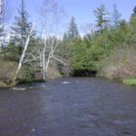
The primary tributaries of Mullett Lake, in descending order of size, are the Indian, Pigeon, Little Sturgeon, and Little Pigeon Rivers and Mullett Creek. Numerous smaller streams also flow into Mullett Lake in various locations. The watershed boundary west of Mullett Lake runs approximately halfway between Burt and Mullett Lakes. In the north part of the watershed, the surface drainage comes to within about one-half mile of Douglas Lake. Mullett Creek drains this portion of the watershed and discharges near the mid-point of the western shore. The northeastern boundary of the watershed lies between Mullett and Long Lakes. The watershed attains its greatest width here, nearly 13 miles. Southeast of Mullett Lake, four small lakes are located within the watershed. Devereaux and Cochran Lakes are seepage lakes, while Silver and Roberts Lakes are drainage lakes with surface connections for Mullett Lake. Four of Mullett Lake’s five major tributaries flow into the south end of the lake. The longest of these tributaries is the Pigeon River, whose headwaters lie approximately 35 miles south of its mouth. The Mullett Lake Watershed has its greatest length here, 46 miles on a north-south axis. The Pigeon River discharges into Pigeon Bay after flowing through a wetland area.
The mouth of the Little Sturgeon River discharges into the Indian River just downstream from the town of Indian River. The Sturgeon River was formerly a tributary of Mullett Lake, also emptying into the Indian River, but its channel was diverted into Burt Lake to facilitate navigation on the Inland Waterway. The Little Pigeon flows into Mullett Lake near the mouth of the Pigeon River. The Indian River is formed from the surface outflow from Burt Lake. It flows through a large cattail marsh, called the Indian River Spreads, before discharging into Mullett Lake.
The outlet of Mullett Lake is the Cheboygan River. In approximately 1922, a dam was constructed on the river four miles downstream from Mullett Lake. The damming caused the lake level to rise, resulting in increased shoreline erosion, which is still occurring at the present time. The damming also resulted in flooded bays and inlets, and some areas of submerged timber. The dam is equipped with a lock to allow boat traffic to access Lake Huron. The Watershed has been divided into six subwatersheds. Five of the sub-watersheds are areas drained by the lake’s major tributaries, and the sixth subwatershed consists of shoreland areas with no major surface streams.
Additional Publications:
| Title | Link |
|---|---|
| 2024 Mullett Lake, Lower Black/Cheboygan Rivers Watershed Management Plan | |
| 2024 MAPS Indian River Chloride Project | |
| 2016 Mullett Lake Shoreline Survey | |
| 2015 Mullett Lake Partial Aquatic Plant Survey | |
| 2009 Mullett Lake Profile CWQM | |
| 2007 Mullett Lake Aquatic Plant Survey |