Description:
Geographic Description:
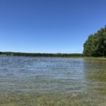
Larks Lake Shoreline
Larks Lake has approximately 4 miles of shoreline. About 1.5 miles (37.5%) of lakeshore frontage is in residential development and 2.5 miles (62.5%) are currently undeveloped. About 1.74 miles of undeveloped frontage is characterized by wetland vegetation and soils.
West Branch of the Maple River
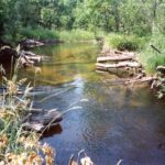
The Maple River is a tributary to Burt Lake. The West Branch of the Maple River originates in a large wetland called the Pleasantview Swamp, and is supplemented by the inflow of Brush Creek which drains from Larks Lake.
Pleasantview Swamp
Covering 6,544 acres, this is one of the biggest, uninterrupted expanses of organic soils in northern Lower Michigan. There are areas of forested swamp, shrub swamp, and emergent marshes. Within the Pleasantview Swamp are four “spring ponds” (called The Four Lakes) that form the headwaters of the Maple River. The swamp has more than 30 miles of shoreline on the Maple River, Brush Creek, 6 Larks Lake, and
The Four Lakes. It is home to most of Michigan’s large reclusive mammals, including bobcat, black bear, and river otter. Bald eagles and ospreys nest in the swamp. Soils consist of Carbondale and Tawas mucks with Roscommon mucky sand along the margins. Fifty-four percent of the swamp is publicly-owned by the State of Michigan (Fuller, 2006).
Land Uses within the Larks Lake Watershed
Pre-settlement land cover (or vegetation present in about 1800) in the Larks Lake watershed was primarily Beech-Sugar Maple-Hemlock forest in the upland areas and cedar swamp in wetland areas (Fuller, 2006). Present day land cover within the watershed includes forest, grassland, wetland, and minor areas of agricultural and residential land
Around Larks Lake, land use is 35% seasonal or permanent residential, 10% recreational (township park) and 55% forested or forest wetland. Approximately 25% of the Larks Lake shoreline is owned by the State of Michigan.
Local Governmental Agencies within the Larks Lake Watershed The Larks Lake Watershed lies within the jurisdiction of the Emmet County government and Center Township. Emmet County administers the zoning for Center Township. The watershed is also within the jurisdiction of a regional government agency- the Northwest Michigan Council of Governments.
Water Quality Review
Larks Lake is a shallow marl lake, and is naturally shallower than most typical marl lakes. Marl sediments are a mixture of clay, sand, and calcium carbonate from limestone that tends to be soft in texture, which is deposited on firm substrates and aquatic macrophytes. All the major lakes of the Cheboygan River Watershed have moderately “hard” water, in reference to the levels of dissolved calcium and magnesium carbonates originating from the limestone bedrock geology of the Watershed and conveyed via groundwater to surface waters (Fuller, 2006). Marl lake deposits are rich in calcium carbonate that precipitates during the photosynthetic processes of aquatic plants, such as Chara (McDonough, 2002).
Sediment in the northwest cove of the lake is organic muck, and muck deposits are deep in this area. Observational depths vary from about six inches to over five feet in depth, as measured with a paddle at various locations. This section of the lake is adjacent to forested wetlands with peat soils. Locally produced organic matter in peat soils will accumulate and bury underlying mineral substrates (Keddy, 2002). Also in the northwest cove there is an area with wood fragments below two to three feet of muck soils. This may be due to the presence of the Carbondale soil series, in which wood fragments are a common component below 12 inches of depth (NRCS, 2004).