Description:
The headwaters of Tannery Creek are in the hills and wetlands by Atkins Rd. to the east of Petoskey. Here, the creek has high water quality and cold temperatures favorable to coldwater fish like brook trout. The nearly-pristine waters flow north from here under E Mitchell Rd., with only small impacts from residential development, and support a diverse array of native vegetation and aquatic organisms.
About a mile downstream, the impacts of urban development begin to pick up. After the creek flows under Country Club Rd., its natural channel is altered and restricted while it flows through the Bay View Country Club and Pirate’s Cove Adventure Golf, before being further restricted by the culvert under US 31. Right after the culvert, the creek makes an unnatural 90 degree and its path is unnaturally straightened. The creek then follows the border of the Glen’s North Plaza through a small forested corridor. This corridor is forested with magnificent large cottonwoods and hardwoods, but also many non-native plants such as giant knotweed, common buckthorn, and garlic mustard. In this corridor, the creek flows through the concrete remnants of an old Tannery, which includes a long concrete channel. By the time water from the creek flows under the Little Traverse Wheelway into Lake Michigan it is warmer, flashier, and carries higher levels of chlorides—all impacts of the surrounding urban development.
Thankfully, Tannery Creek is a focus of restoration efforts. Funding from the Environmental Protection Agency (EPA)’s Great Lakes Restoration Initiative was provided to replace the existing perched culvert under the Little Traverse Wheelway with a clear-span bridge, thereby naturalizing the river’s flow and allowing better passage of aquatic organisms. Funding was also provided to control invasive species in the vegetation corridor by the mouth. Students from the University of Michigan School of Natural Resources and Environment (SNRE) developed a Tannery Creek Watershed Management Plan and conducted outreach to local individuals and businesses. Below is the results of their project.
Crucial Creeks Master’s Project Tannery Creek (Little Traverse Bay): A Scale-Appropriate Watershed Management Plan Authors: Elizabeth Lillard, Diana Portner, Julie Riggio, Bo Williams, and Leah Zimmerman – April 2013 Abstract Tannery Creek is one of the main tributaries leading into Little Traverse Bay, which is located adjacent to Petoskey, Michigan. The creek lies within the jurisdiction of the Little Traverse Bay Watershed Protection Plan. The client, Tip of the Mitt Watershed Council (the Watershed Council), asked the project team to research and prepare a watershed management plan for Tannery Creek that would be amended to the Little Traverse Bay plan. The project included an assessment of Tannery Creek’s water quality, a watershed analysis using GIS tools, and a thorough public outreach campaign. For the stream assessment, the project team compiled historical data and conducted sampling at five sites over the course of 2012. For the watershed analysis, the team utilized to primary tools: a land cover model and the Long Term Hydrologic Impact Analysis model. In addition to a description of these activities and their results, the watershed management plan itself includes goals and objectives and a detailed implementation plan. |
Other Threats to Water Quality
- Nonpoint Source Pollution
- Eroding riverbanks
- Urban development

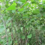
A large stand of Invasive Knotweed near the mouth of Tannery Creek.
Monitoring
Biological monitoring is also performed by volunteers in the Bear River each spring and fall as part of the Watershed Council’s Volunteer Stream Monitoring (VSM) Program.
The Advisory Committee of the Little Traverse Bay Watershed Protection Plan addresses issues that affect the Creek, because they ultimately affect the Bay.
Additional Resources:
Information about Threatened, Endangered, and Special Concern species in this stream’s watershed is available on the Michigan Natural Features Inventory (MNFI) website.
USGS Current Water Data for Michigan provides stream flow conditions.
A wide variety of maps, including Vegetation circa 1800, National Wetlands Inventory, Land Cover Change 1800’s to 1978, Wetland Change 1800’s to 1980, and many other resources for this area are available online in the Michigan Natural Features Inventory (MNFI) Data Resources page.
Learn about safely eating fish from this river in the Michigan Fish Consumption Advisory.
| Title | Link |
|---|