


Description:
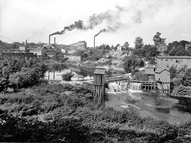
For centuries, the Odawa Indians made their home along the lakeshore of Little Traverse Bay. The strategic location of the Bay on the Great Lakes and its abundant natural resources made it desirable not only for Native Americans, but also for early European settlers. French explorers traveling along the east coast of Lake Michigan found two large embayments along their way. During calm weather, they crossed the bays’ mouths in their canoes to save time. The northernmost bay had a slightly narrower mouth and they called this la petit travers – the little traverse.
The abundance of natural resources, and ease of harvesting and transporting them, made the area’s economy flourish. Lumbering and fur trading were extensive within the Watershed. The Bear River made it easy for transporting logs to the Bay where large ships waited to take them to points all along the Great Lakes. Fishermen harvested whitefish and lake trout from the Bay. Limestone and shale along the south shore of the Bay supported cement manufacturing. In addition to all of the industrial and extractive uses, the natural beauty of Little Traverse Bay also attracted visitors from across the country. By the 1880’s, several resort communities were well established. By the time Michigan became a state, well over 100 years of fur trading, resource extraction and development had already taken its toll on the Watershed.
Ironically, the water resources that continue to enrich the area are still threatened. Overdevelopment, invasive species, and pollution from stormwater runoff are just a few of the threats they face today. The balance of supporting the local economy while preventing resource degradation is an ongoing challenge.
Image courtesy of Little Traverse Historical Society. |
|

 | Resiliency Plan for Governments in the Little Traverse Bay Watershed: LOCAL CLIMATE SOLUTIONS Thanks to the generous support of the Petoskey-Harbor Springs Area Community Foundation we were able to produce the “Resiliency Plan for Local Governments in the Little Traverse Bay Watershed.” The purpose of this report is to help inform natural resource managers and local officials about expected impacts from our changing climate and help local governments make our coastal cities resilient to these changes. Information and resources found in the document also support the overarching goals of the Little Traverse Bay Watershed Protection Plan. |
 | Little Traverse Bay Watershed Protection Plan – 2007-2012 and Beyond Brochure highlights the accomplishments of the Plan from 2007-2012. |