fbpx
Search
Close this search box.
Protecting Northern Michigan's ​Water Resources

Eastport Creek

Eastport Creek is a small, clear creek that drains into Torch Lake, which is the largest inland lake in Michigan by depth and volume, and second largest by surface area (behind Houghton Lake, which is much shallower). Eastport Creek has excellent water quality, especially toward its headwaters.

Overview of Eastport Creek

Watershed

Mouth

North end of Torch Lake

Surface Area

0 acres

Shoreline

Maximum Depth

Length

8.25 miles

Known Aquatic Invasive Species

Description:

Eastport Creek is a small, clear creek that drains into Torch Lake, which is the largest inland lake in Michigan by depth and volume, and second largest by surface area (behind Houghton Lake, which is much shallower). Eastport Creek has excellent water quality, especially toward its headwaters. 

The stream system has two unnamed tributaries. The longest of these tributaries is about four miles long. One branch of Eastport Creek originates in swampy interdrumlin swales, and another in a swampy lake plain near Lake Michigan. A short portion of the stream flows through Antrim County’s Barnes Park, otherwise there is no public land along the stream. The greatest elevation of the Creek’s headwaters is 820 feet. The stream drops 229 feet in elevation, for an average stream gradient of about 57 feet per mile.  The stream system is crossed by U.S. 31, Scenic Highway (M-88), and Lore and Ferrel Roads. At M-88, the stream is about six feet wide and six inches deep, with a sand-gravel bottom. Thermal characteristics of the stream indicate that it has moderately-high ground water inputs. Estimated streamflow is about three CFS. The stream water is slightly stained and clear. The stream is located in Banks and Torch Lake Townships (Antrim County). It is shown on the Atwood and Central Lake 7.5 minute U.S.G.S topographic maps. Eastport Creek is designated as a trout stream by the MDNR.

Picture
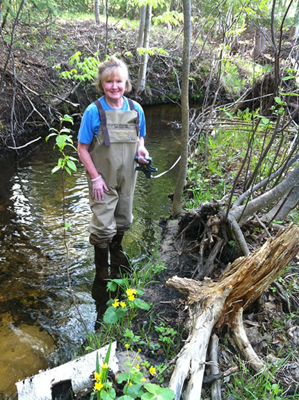
Monitoring

Biological monitoring is performed by volunteers in Eastport Creek each spring and fall as part of the Watershed Council’s Volunteer Stream Monitoring (VSM) Program.

Other Threats to Water Quality
  • Nonpoint source pollution
  • Eroding riverbanks
  • Agriculture
  • Shoreline development

Additional Resources:

Additional Resources

Information about Threatened, Endangered, and Special Concern species in this stream’s watershed is available on the Michigan Natural Features Inventory (MNFI) website. 

Discharge data for this stream is available online through the Michigan Department of Environmental Quality’s Low Flow Discharge Data Base.

USGS Current Water Data for Michigan provides stream flow conditions. 

A wide variety of maps, including Vegetation circa 1800, National Wetlands Inventory, Land Cover Change 1800’s to 1978, Wetland Change 1800’s to 1980, and many other resources for this area are available online in the Michigan Natural Features Inventory (MNFI) Data Resources page.

Learn about safely eating fish from this river in the Michigan Fish Consumption Advisory.

TitleLink

Insert Eastport Creek Map