fbpx
Search
Close this search box.
Protecting Northern Michigan's ​Water Resources

Black Lake Watershed

The Black Lake Watershed is well known for its recreational opportunities and aesthetic appeal. Boating, swimming, and fishing are popular activities among year-round residents, seasonal residents, and tourists. Not only is Black Lake itself heavily utilized, but many tourists come to the area to enjoy the Pigeon River Country, hunting, fishing, and canoeing/kayaking opportunities afforded by the Black River.

Overview of Black Lake Watershed

Rivers in the Watershed

Lakes in the Watershed

Size

350,000 acres

Watershed Management Plan

Link to Watershed Management Plan

Description:


The Black Lake Watershed is well known for its recreational opportunities and aesthetic appeal. Boating, swimming, and fishing are popular activities among year-round residents, seasonal residents, and tourists. Not only is Black Lake itself heavily utilized, but many tourists come to the area to enjoy the Pigeon River Country, hunting, fishing, and canoeing/kayaking opportunities afforded by the Black River.

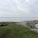
Black Lake has a healthy and diverse fishery resource. The Lake is famous for its population of lake sturgeon that is self-sustaining, but is threatened. A very limited fishing season, every February, allows for five lake sturgeon to be harvested. The Lake’s fishery also includes muskellunge, northern pike, yellow perch, walleye, and bass. 

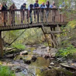
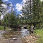
The major rivers within the watershed are also important recreation areas. Canada Creek has a community of permanent and seasonal residents, called Canada Creek Ranch, who mostly live along the riverbank or on the shoreline property of Lake Geneva and the other small lakes within the development. Kleber and Tower Ponds on the Upper Black River also are heavily used for recreation. Tomahawk Creek, Canada Creek, and the East Branch of the Black River are located in areas favored by hunters and anglers, as well as hikers and campers.

The Pigeon River Country State Forest encompasses about 120 square miles, much of which is in the Black Lake Watershed. It is the largest contiguous block of state-owned land in Michigan’s Lower Peninsula. The area is managed separately from other state forest lands in the area. Because of the unique features within the forest (Michigan’s only elk herd, numerous high quality rivers and lakes, and the wilderness atmosphere of the area), more protective land and water management policies are in place than on most state forest lands. Work is ongoing to preserve, protect, and enhance the wildlife corridors and habitat in the area outside of the boundaries of the Pigeon River Country State Forest.

Geographic Description:

The Black Lake Watershed is large, encompassing 547 square miles or 350,000 acres. It comprises 37.7 percent of the 1,461-square-mile Cheboygan River Watershed. A ratio of the size of Black Lake’s watershed to the surface area of the Lake (watershed-to-surface area ratio) can be a helpful tool in determining how susceptible a lake and its tributaries are to pollution. Lakes in which the ratio of watershed area to lake area is high are more susceptible to nutrient enrichment and other types of pollution throughout the watershed than lakes with small ratios. Black Lake’s watershed is 35.04 times larger than the surface area of the Lake (a ratio of 35.04:1, or simply 35.04). This is fairly high for large lakes in Northern Michigan. For example, the watershed-to-surface area ratio for Burt Lake is 14.8 and for Mullett Lake, only 9.74.
The Black Lake Watershed lies between the Mullett Lake Watershed on the west; the Thunder Bay Watershed to the south; and in the north and east the Lake Huron Watershed. In the north and northeast portion of the Black Lake Watershed, the boundary lies about a mile and a half north of the Lake itself, generally following the contour of the shoreline. On the east side, south of the Bearinger-North Allis Township line, the boundary of the watershed extends eastward, reaching its eastern-most point about halfway between Rainy and Emma Lakes in the southern part of Presque Isle County. It is here that the watershed reaches its maximum width of 21 miles. The boundary begins to bend back west and south, staying north of Atlanta except for a slight dip south about a mile north of Double Lake in Montmorency County. Here is the southernmost extent of the watershed; it reaches a maximum length of 36 miles. From there, the watershed boundary follows a line almost straight west, through the town of Hetherton and west another six miles. Then it bends northward and the western edge of the watershed runs nearly straight north-south from highway M-32 in Otsego County to Devereaux Lake Road in Cheboygan County. There it cuts in sharply to the shore of the northwest corner of Black Lake, at the Lower Black River.

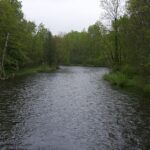
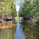
Several rivers and streams flow into Black Lake. The major tributaries to the Lake are the Upper Black River (57 river miles) and the Rainy River (24 river miles). Additionally two major rivers flow into the Upper Black and indirectly into Black Lake: Canada Creek and the East Branch (21 river miles each). Other important tributaries include Tomahawk Creek, Milligan Creek, Stony Creek, Mud Creek, Hardwood Creek, Van Hellens Creek, Rattlesnake Creek, Packer Creek, and Fast Creek. Numerous smaller streams also flow into Black Lake and its tributary rivers.

The watershed contains mostly forested and open space, much of which is state land. Agriculture uses comprise a relatively small percentage of the entire watershed. Besides Onaway, Canada Creek, and Tower there are minimal amounts of urban areas mostly
contained in several small communities and strips of residential development along roads and shorelines.

Additional Publications:

TitleLink
Comprehensive Water Quality Monitoring (CWQM)
2018 Black Lake Tributary Study
2017 Black Lake Shoreline Survey
2014 Black Lake Aquatic Plant Survey