Description:
Paradise Lake, formerly known as Carp Lake, is a large, shallow drainage lake in northern Emmet County. The tannin-stained water of the lake is dark in color, yet high quality. The lake supports a vibrant fishery, including large predatory pike inhabiting its depths.
Paradise Lake is approximately 3 miles long, gradually widening from east to west with two distinct lobes on the western end split by Stony Point. Another prominent point, Ashbaugh Point, is located on the western end of the northern shore. The area to the west of this point is referred to as Carlton Cove. The lake is fed by Mud Creek, which stretches about 8 miles to the east. Paradise Lake drains through the Carp River into Lake Michigan at Cecil Bay, which is just east of Wilderness State Park.
The majority of the Paradise Lake is less than 10 feet deep. The deepest spot is located in a narrow, long trough that extends east to west along the northern half of the lake across most of the lake. A shallow plateau of five feet of depth and less is found in the center of the lake.
Paradise Lake is a popular lake for recreation enthusiasts, including paddlers, fishermen, boaters and swimmers. The town of Carp Lake rests alongside US-31 on the western shore of the lake. Numerous Little Traverse Conservancy preserves exist along Paradise Lake’s southern shore.
Public Access Sites:
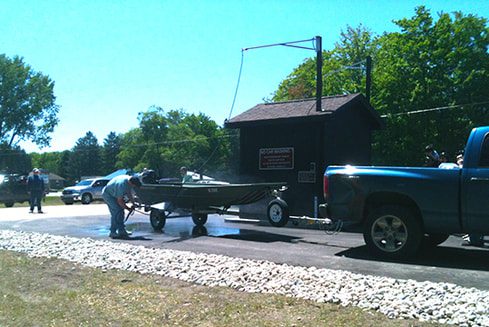
A Department of Natural Resources boat launch is situated near the center of the west shore of the lake. In 2013, a boat washing station was installed at this site by the Little Traverse Bay Bands of Odawa Indians, working in cooperation with the Michigan Department of Natural Resources, and the Paradise Lake Improvement Board. The project was funded with the Great Lakes Restoration Initiative grant from the U.S. Environmental Protection Agency. When used, the boat washing station will help prevent the spread of aquatic invasive species from one lake to another.

Monitoring and Research:
Paradise Lake is monitored every three years through the Watershed Council’s Comprehensive Water Quality Monitoring (CWQM) Program for dissolved oxygen, specific conductivity, pH, nitrate-nitrogen, total nitrogen, total phosphorus, and chloride levels.
Water transparency, chlorophyll-a, and water temperature are also monitored in Paradise Lake each summer by volunteers as part of the Watershed Council’s Volunteer Lake Monitoring (VLM) Program.
Additional Resources:
See additional resources on our Aquavist page.
View an interactive map, including public access sites, at Michigan Fishweb.
A wide variety of maps for this area are available online at the Michigan Natural Features Inventory (MNFI) Data Resources page.
Information about Threatened, Endangered, and Special Concern species in this lake’s watershed is available on the Michigan Natural Features Inventory (MNFI) website.
Learn about safely eating fish from this lake in the Michigan Fish Consumption Advisory.


