 You can’t start at the mouth of the Boyne River and swim upstream to some of the tallest hills in Michigan’s Lower Peninsula without running into some obstacles. In fact, there are three impoundments frustrating the river that is Lake Charlevoix’s second largest tributary, two of which are formed by dams. However, these three impoundments, and a handful of faulty road/stream crossings, have not managed to exhaust the river; the Boyne River maintains stellar water quality, strong ecological diversity, and some of the best fishing and canoeing you can find in Northern Michigan.
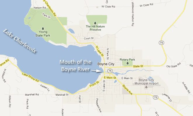
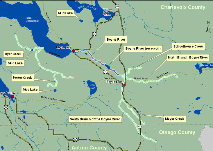
The first impoundment, the Boyne City Mill Pond, is located within the City limits and not too far from the river’s mouth. This impoundment isn’t the product of any dam, but does have similar effects on the river, because the pond collects sediments and raises the temperature of the water downstream. Called Little Lake in the 1901 Plat Book, the pond has been heavily used by various industries in Boyne City.
The second impoundment you would reach is the 80 acre reservoir behind the Boyne USA Power Plant Dam. The dam and power plant were built in the early 1900s to provide electricity, and the reservoir is now completely surrounded by private property. Because the dam prevents anadromous fish from swimming upstream, it has divided the river into two distinct fisheries: steelhead and salmon are caught downstream of the dam, while upstream of the dam is an excellent brook and brown trout fishery with some sections designated as Blue Ribbon Trout Stream by the Michigan Department of Natural Resources.
There are two branches of the Boyne River that split above the Boyne USA Power Plant Dam: the North Branch, with headwaters in eastern Charlevoix County, and the South Branch, with headwaters in Otsego and Antrim Counties. The North Branch has no dams or impoundments along its length, but the South Branch does have one. This is the reservoir created behind the M-75 dam at Boyne Falls. This dam was built in the 1800s and powered both a saw mill and a grist mill, which ground grain into flour. The reservoir used to be deep enough to sustain a great brown trout fishery, but has filled in with sediment and is now shallow.
About the Boyne River
In ancient times, a band of Native Americans lived near the mouth of the Boyne River. “Evidence of Indian mounds was discovered within the City limits during the dismantling of the old chemical works.” (Reported by the Citizen, June 26, 1930)
The first settlers arrived in the 1850’s. As time passed, the forests of Michigan were recognized as a value almost beyond measure. There were many fortunes to be made and the mouth of the Boyne River where it flowed into Lake Charlevoix was a perfect place to build a city to handle the millions of logs that were being produced. Lake Charlevoix offered deep water about 16 miles inland from Lake Michigan. The ships that hauled the lumber could sail closer to the virgin trees. Boyne City was born.
With the coming of the railroads, Boyne Falls became a logging town at the end of the tracks that bustled with immigrant lumberjacks. The logging activities attracted other businesses and soon Boyne City was a highly industrialized community. These were hard times for the environment. There were few, if any, guidelines for growth. The forests were devastated into fields of stumps and all sorts vile things flowed into the Boyne River and Lake Charlevoix.
From this environmental low point, things began to change. The logs ran out. The industries failed. The economy in the valley suffered drastically, but the wounds upon the land began to heal. The water quality improved, the hills reforested and the beauty of the valley returned, not exactly as it was, but the valley is beautiful again. Now, the economy is based on the high quality of life that the beautiful Boyne River Valley affords. People come here to live, to retire, to vacation. Conserving the environment has become a high priority.
During the depression the Boyne River was “cherished” because it provided food and livelihood for hard pressed residents. “Boyne River is Boyne City’s most cherished treasure” (The Citizen, June 26, 1930)
Today the Boyne River is “cherished” because it contains high quality fresh water that supports great biodiversity. Water of this quality diminishes yearly in Michigan, the United States and throughout the world. The River is the focal point for the Friends of the Boyne River and is enjoyed by residents and many visitors.
The Naming of the Boyne River
When John Miller, an Irish immigrant, settled at the east end of the North Arm of Pine Lake, (now Lake Charlevoix), he named the river flowing there after the revered “River Boyne” in his homeland. The Boyne River in Ireland begins its 70 mine journey at Trinity Well in County Kildare. It passes by Tara Hill and flows into the Irish Sea near Drogheda. The River is steeped in Irish history, myth and legend. As many as 142 Kings may have reigned near Tara Hill in prehistoric and historic times.
River Facts
The Boyne River Main Stream
The Boyne River main stream is 5.6 river miles long from its mouth at Lake Charlevoix to the junction of the North Branch and the South Branch just north of Boyne Falls.
The Boyne River North Branch
The Boyne River North Branch is 5.9 river miles long from the junction of the North Branch and the South Branch just north of Boyne Falls to its source just west of Thumb Lake.
The Boyne River South Branch
The Boyne River South Branch is 10.5 river miles long from the junction of the North Branch and the South Branch just north of Boyne Falls to its source just south of Elmira.
Did you know?
- Parts of the Boyne River are designated as a Blue Ribbon Trout Stream by the Michigan DNR.
- The Watershed Council has been monitoring the Boyne River since 2004 in our Comprehensive Water Quality Monitoring program, which collects data on temperature, dissolved oxygen, conductivity, ph, nitrate-nitrogen, total nitrogen, total phosphorus, and chloride concentration.
- If you search hard for bugs in the Boyne River, you man find the fierce pinching larvae or heavily-armored adult form of a predacious diving beetle in the family Dytiscidae.
- The watershed of the Boyne River is about 63 square miles.
- The Tip of the Mitt Watershed Council has developed a new system to “score” the water quality of a stream site based on the numbers of Families, EPT (mayfly, stonefly, and caddisfly) Families, and sensitive Families of macro invertebrates found. The score is based is assigned a letter grade like in school. The Boyne River sites typically score an A or a B, and ofter score an A+, which indicates high water quality.
- The giant, prehistoric, armor-plated, pollution-sensitive, herbivorous stonefly in the genus Pteronarcys has been found at all four sites monitored on the Boyne.
- The Boyne River Watershed is bordered by the Bear River to the north, the Sturgeon to the east, the AuSable and Manistee to the south, and Jordan to the west-southwest.
- There are two man-made dams on the Boyne river, at Dam Road and Boyne Falls, which create barriers to fish passage and elevate water temperatures; elevated water temperatures can affect pollution-sensitive aquatic organisms, such as Brook Trout and stoneflies.
- The Boyne River originates near some of the highest hills in the Lower Peninsula (Chandler Hill) with Hudson Lookout to the south of Thumb Lake reaching over 1500 feet above sea level.
- The Boyne is an enjoyable 1-2 hour paddle from Dam Road down to Lake Charlevoix.