Duncan and Grass Bays Watershed Protection Plan:
The Duncan and Grass Bays Watershed Protection Plan (Plan) is the result of applying the watershed approach to managing water resources within the Duncan and Grass Bays Watershed (Watershed). The Plan takes into account the known sources and causes of the priority nonpoint source pollutants, the areas within the Watershed most impacted by these pollutants, and the measures necessary to protect or enhance water quality throughout the Watershed. The Plan is a tool and a guide to future management efforts based on the needs of the Watershed and capacity of its stakeholders.
Geographic Description:
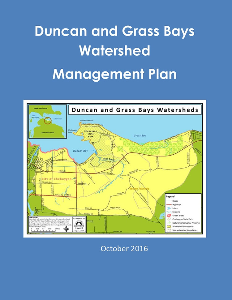
Duncan and Grass Bays are located on Lake Huron in Cheboygan County in the northern tip of the Lower Peninsula of Michigan. The shorelines of the Bays fall within Benton Township and the City of Cheboygan. Duncan Bay extends eastward from the Cheboygan River outlet in the City of Cheboygan to the tip of the peninsula jutting forth on the east side of Cheboygan State Park. The straight‐line distance from the river to the peninsula tip is approximately two miles, whereas the more pronounced foot of the Bay, near the Duncan Bay Club and the State Park, measures less than a mile across. Grass Bay is broad, stretching five miles from the tip of the Cheboygan State Park Peninsula east to just past Cordwood Road. Based upon digitization of aerial orthophotographs (Cheboygan County 2008), the Duncan Bay shoreline measures approximately 6 miles and Grass Bay just over 5 miles of shoreline. The majority of Duncan and Grass Bays are shallow with depths of less than 20 feet.
Based on GIS files developed by the Watershed Council using existing watershed boundary and elevation data from the State of Michigan, the Duncan Bay Watershed encompasses 8,088 acres and the Grass Bay Watershed covers 3,838 acres. Land cover statistics for the Duncan and Grass Bays Watershed were generated using remotely sensed data from the Coastal Great Lakes Land Cover project (Table 4 and Table 5). Based on the 2010 data, there is little agricultural landcover within the Duncan Bay Watershed (~5%), but a relatively high amount of urban land cover for Northern Michigan watersheds (11%). The Grass Bay Watershed has less than 3% of agricultural and urban land cover types combined. The
majority of land cover in both watersheds consists of forests and wetlands.
The Nature Conservancy’s Grass Bay Nature Preserve: Grass Bay Preserve extends along two miles of Lake Huron shoreline and includes over 300 plant species. Three species of wildflowers found at Grass Bay are endemic to the Great Lakes—the dwarf lake iris (blooming in purple or white), Pitcher’s thistle, and Houghton’s goldenrod. Neotropical migrants such as the black‐throated blue warbler and the prairie warbler can also be observed at the Preserve. The Preserve includes sandy and cobble shorelines wither emergent wetlands, open dunes, interdunal wetlands, coniferous swamps and forests, and home to twelve of Michigan’s thirteen coniferous species.
The Nature Conservancy first became aware of Grass Bay’s diverse flora in 1978. When the original 80‐acre parcel went on the market in 1979, the Conservancy secured an option to purchase it. Because the Federated Garden Clubs of Michigan treasured this site and also wanted to see it protected, they launched a very successful multi‐year campaign to raise money to assist the Conservancy in purchasing the original parcel, plus approximately 100 more acres soon after. Since its initial purchase, several land donations and purchases have expanded the Grass Bay Preserve to its current 956.2 acres. In order to protect the site from inadvertent ecological damage due to overuse, access is limited to Conservancy field trips and research opportunities. (Source: www.nature.org)
Cheboygan State Park
Source: Michigan Department of Natural Resources
Cheboygan State Park is approximately three miles east of the City of Cheboygan. The park has seven miles of Great Lakes frontage and includes coastal marshes, cobblestone and sand beaches, open sand dunes, and interdunal wetlands. A small boat launch provides access to Duncan Bay. Some of the best fishing in the area, with northern pike, small and large mouth bass, and several types of pan fish can be found in Duncan Bay. Elliot Creek, also known as Little Billy Elliot Creek, is well known for its speckled brook trout.
• Benton Township • Bring It Cheboygan • Cheboygan Conservation District • Cheboygan County Drain Commissioner • Cheboygan County Road Commission • Earth Week-Plus, Cheboygan • Great Lakes Tissue Company • Huron Pines • James McClurg, resident • Knicos Family, residents | • Little Traverse Conservancy • Little Traverse Bay Bands of Odawa Indians • MI Dept. of Environmental Quality • MI Dept. of Natural Resources • Mullett Lake Area Preservation Society (MAPS) • Natural Resource Conservation Service (USDA) • Northeast MI Council of Governments • Paul Salvatore, resident • Roger Benter DC, resident • Roger Gauthier, resident | • Straits Area Concerned Citizens for Peace, Justice, and the Environment (SACCPJE) • Sturgeon for Tomorrow • The Nature Conservancy • Tip of the Mitt Watershed Council • Top of Michigan Trails Council • Val and Phil Porter, residents |
Additional Publications:
| Title | Link |
|---|